
- Rajasthan
- Kerala
- Maharastra
- Tamilnadu

 City : Kanyakumari
 Location : South India
Language : Tamil, Kannad, Telugu, Malayalam, Hindi
About Kanyakumari
Kanyakumari is a town in Kanyakumari district in Tamil Nadu state, India. Located at the southernmost tip of the Indian Peninsula, it is also called Cape Comorin. The closest major cities are Nagercoil, the administrative headquarters of Kanyakumari district, (22 km) and Thiruvananthapuram, the capital of Kerala (85 km).
A popular tourist place in India, the town and the district, Kanyakumari District, in which it is located, is a place of great natural beauty - from the blue seas of Kanyakumari town to the blue hills of the Western Ghats in the interior.
A popular tourist place in India, the town and the district, Kanyakumari District, in which it is located, is a place of great natural beauty - from the blue seas of Kanyakumari town to the blue hills of the Western Ghats in the interior.
History
Kanyakumari takes its name from the Kumari Amman or Kanyakumari Temple, situated in the town, on the sea-shore, the very confluence of the three water-bodies - Bay of Bengal, Indian Ocean and the Arabian Sea. According to local lore, Kanya Devi, an avatar of Parvati, was to marry Shiva, but as he failed to show up on his wedding day, the rice and other grains meant for the wedding feast remained uncooked and remain unused thereafter. As the local lore goes, the uncooked grains turned into stones as time went by. Some believe that the small stones which look like rice on the shore today, are indeed grains of the wedding that was never solemnized. Kanya Devi is now considered a virgin goddess who blesses pilgrims and tourists who flock the town.
Geography
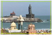
Kanyakumari - Vivekananda Rock Memorial and Thiruvalluvar Statue at sunriseKanniyakumari is located at 8.08° N 77.57° E. It has an average elevation of 0 metres (0 feet). It lies at the meeting point of the three bodies of water: the Arabian Sea, the Bay of Bengal and the Indian Ocean. It is situated at 8° 4' 41 N, 77° 32' 28? E, and is the terminating point of the Western Ghats and Eastern Ghats. On the north and the east, it is bounded by Tirunelveli District, while on the west and northwest it is bounded by Kerala state.